https://doi.org/10.2193/2008-512
As the range of coyotes (Canis latrans) in northeastern regions of the United States increases, human-coyote interactions (HCI) have become a more prevalent issue in suburban and urban areas. The authors of this article focused their research of HCI in Westchester County, New York, distributing 6,000 surveys to students kindergarten to 12th grade. Each survey asked if the family members had seen or heard a coyote within the past 3 years: how many, at what time of day, and at what time of year? The students address was attached to these answers in order to geographically place them as data points. The sightings data was also compared to a rural-urban gradient based on the intensity of development (density of infrastructure/buildings).
When considering the methodology of their sampling, it is important to consider that they employed a voluntary response method. Although the authors mentioned that over 1,500 responses from the households of the students gave a spectrum of land use types (rural, suburban, urban), this variability could have been accounted for better if they had used the documented reports of HCI from local police departments as their sampling frame and then chose their sample size from simple random sampling within each source of reports (stratified sampling). This would have decreased the possibility of response bias since there might be a confounding variable to consider when assessing who had taken the time to fill out the survey (perhaps those who had encountered a coyote more frequently were more likely to share their story than others).
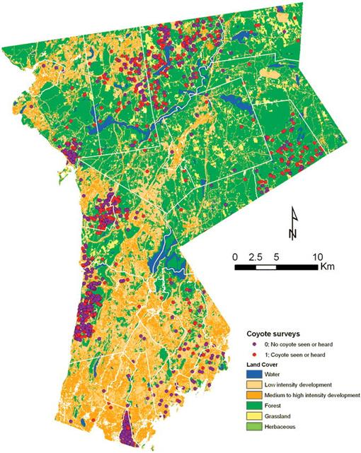
The data was found to show the following trends: visual sightings increased closer to nighttime, most sightings were of solitary coyotes across seasons, encounters were most likely to be closer to forest and grassland land cover types and farther from medium to high intensity development. The collective findings were then used in conjunction with previous coyote sightings data to formulate a map of Westchester County, NY depicting the probability of coyote observation.
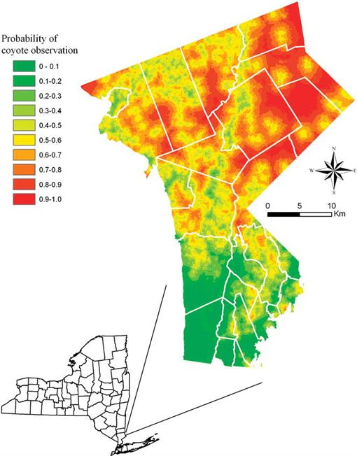
Having a map with the probability of human-coyote interactions can lead to more focused management techniques. Areas which are at high risk for encounters could have more educational outreach from local government agencies to minimize attracting coyotes (practices such as keeping pet food and garbage secure). Also, these areas could benefit from greater awareness of the presence of coyotes so that preventative measures and active engagement in environmental issues from residents could lead to a proactive mindset and willingness to share their space with a predator species. This article is also significant in the way that it highlights the use of citizen science to quantify human-wildlife interactions. Making use of residential viewpoints and modern technology can gather data at a more efficient rate than experimental study sites. This connection between citizen science and human-wildlife interactions in an urban setting can be seen in many other papers (https://doi.org/10.1071/WR10007 = citizen science and tagged urban wildlife, HTML = citizen science and Tuscon Bird Count, https://doi.org/10.1371/journal.pone.0156425 = citizen science and birds/ butterflies.